
Farming is a complex and often uncertain operation, due to factors such as weather, machine performance, and yield. The planning of farming operations can typically involve four highly interconnected stages:
- Harvesting
- Out-of-field removal of biomass
- Rural road transportation, and
- Public road transportation.
The corresponding machinery systems include harvesters, transport units, medium and high capacity transport trucks, and unloading equipment between the various stages.
To optimize their operations, farmers need to be able to track, monitor, and know exactly where their machines are on their land. Knowing that a tractor or harvester is somewhere on the farm, without specifics regarding functionality, fuel level, work output, etc, offers no real value or insight to the farmer.
Agricultural fleet management is a key factor to farming success and optimization.
Our approach to agricultural fleet management
A partner approached 3Dtracking with a request to solve the problem of tracking farming machinery/vehicles on a farm.
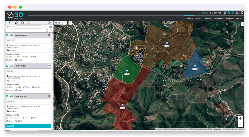
Knowing their operational status and efficiency, we decided to create a solution on our telematics platform to enable a farmer/ farm manager to be able to view their farm in accordance with various points of interest (POI). These POIs are created according to the particular functions of the farm (see image below).
When a farmer is looking for a particular vehicle, they can now see where that vehicle is, at any point in the day, and whether that vehicle is operational in that specific location.
Image 1. Screenshot showing POIs
We then added the additional functionality of fuel tracking to the solution and used this data to measure and provide insights such as distance covered or working hours in relation to fuel usage.
Image 2. Screenshot showing fuel consumption report
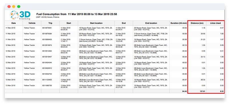
Fuel dispensing at the farm fuel depot was also added to provide further monitoring of fuel usage, in relation to ‘work’ achieved in the fields. This helped to improve the management of fuel and avoid theft and /or wastage (vehicles idling unnecessarily).
Tracking valuable agricultural equipment
In the case of portable devices or asset trackers used to track valuable equipment, these can also be located and monitored by the system, and reports and or alerts can be set up for the management of these. If vehicles, such as a tractor, have a CanBus device, 3Dtracking’s platform is also able to present relevant information such as oil temperature, fuel level, speed, RPM, etc.
Developing calculations
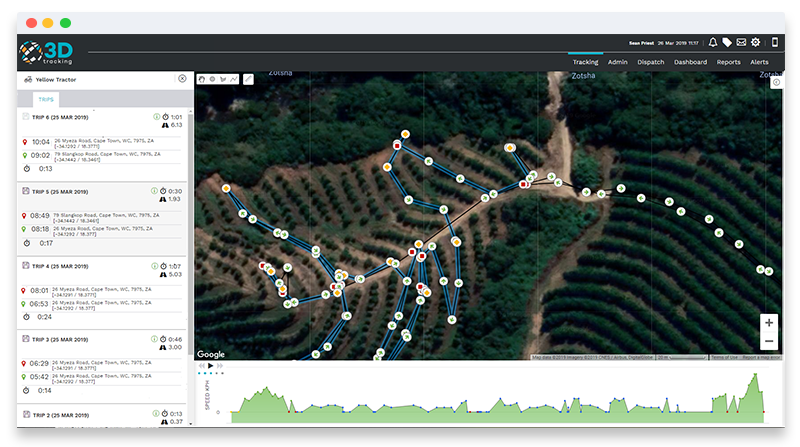
Further calculations were developed, utilizing a vehicle’s capability - for example, the area covered by a sprayer. When the sprayer is switched on, that input is registered on the system and shows up on the screen as a thicker tracking line. Taking into account the sprayer width, in relation to location, we can calculate the total area covered when the sprayer was active, and at what fuel cost.
This insight offers farmers an enormous advantage in understanding their equipment’s efficiencies or lack thereof. Furthermore, the 3Dtracking platform provides the farmer with the knowledge of the area the machinery worked on, and what areas are still to be covered or have not been worked on.
Image 3. Screenshot showing when the sprayer was switched on (thicker blue line) versus off (thin black line)
What's included in a report?
The 3Dtracking platform allows the farmer to set up and receive specific alerts and reports that could include:
- Areas covered (based on the POIs)
- Driver authentication
- Working hours
- Fuel consumption
- Driver behavior
- Service and maintenance
The overall solution provides farmers with an industry-tailored solution that helps to address the problems they were facing in monitoring their equipment, areas worked, and fuel.
If you would like to find out more about 3Dtracking or book a free demo, please contact us.
References
www.researchgate.net/publication/267330907